Expertise
Complex highway projects require meticulous planning and consideration. At SMEC, Geographic Information Systems (GIS) technology has emerged as a powerful tool, adding value for our clients and partners across all stages of the project lifecycle as well as ongoing asset management.

At the Marine Drive Expressway, Bangladesh, SMEC’s application of GIS has brought significant improvements in cost reduction during the design phase of the project whilst improving the quality of the design. By leveraging GIS mapping technology during the feasibility and preliminary design stages, the project has witnessed positive changes that have enhanced decision-making and accelerated progress.


Marine Drive Expressway includes hundreds of structures including bridges, viaducts, culverts and interchanges with six river crossings.  The GIS identified over 80 kilometres of coastal protection. The expressway’s preliminary design features six expressway lanes in the northern section and four in the southern section, 10 interchanges (with rest areas at 50-kilometre intervals); and numerous drainage structures.


In this article we discuss three value adds identified by SMEC during the planning phase of the project.


Optimising alignment with drone surveys and Multi Criteria Analysis

Drone-based topography, combined with GIS, has played a crucial role in identifying and accessing survey areas. GIS assisted in planning the survey, including determining launch stations and analysing the drone images for updated ground conditions. Providing real-time data via web based GIS, enabled both the internal team and the client to monitor and respond to the evolving situation effectively.


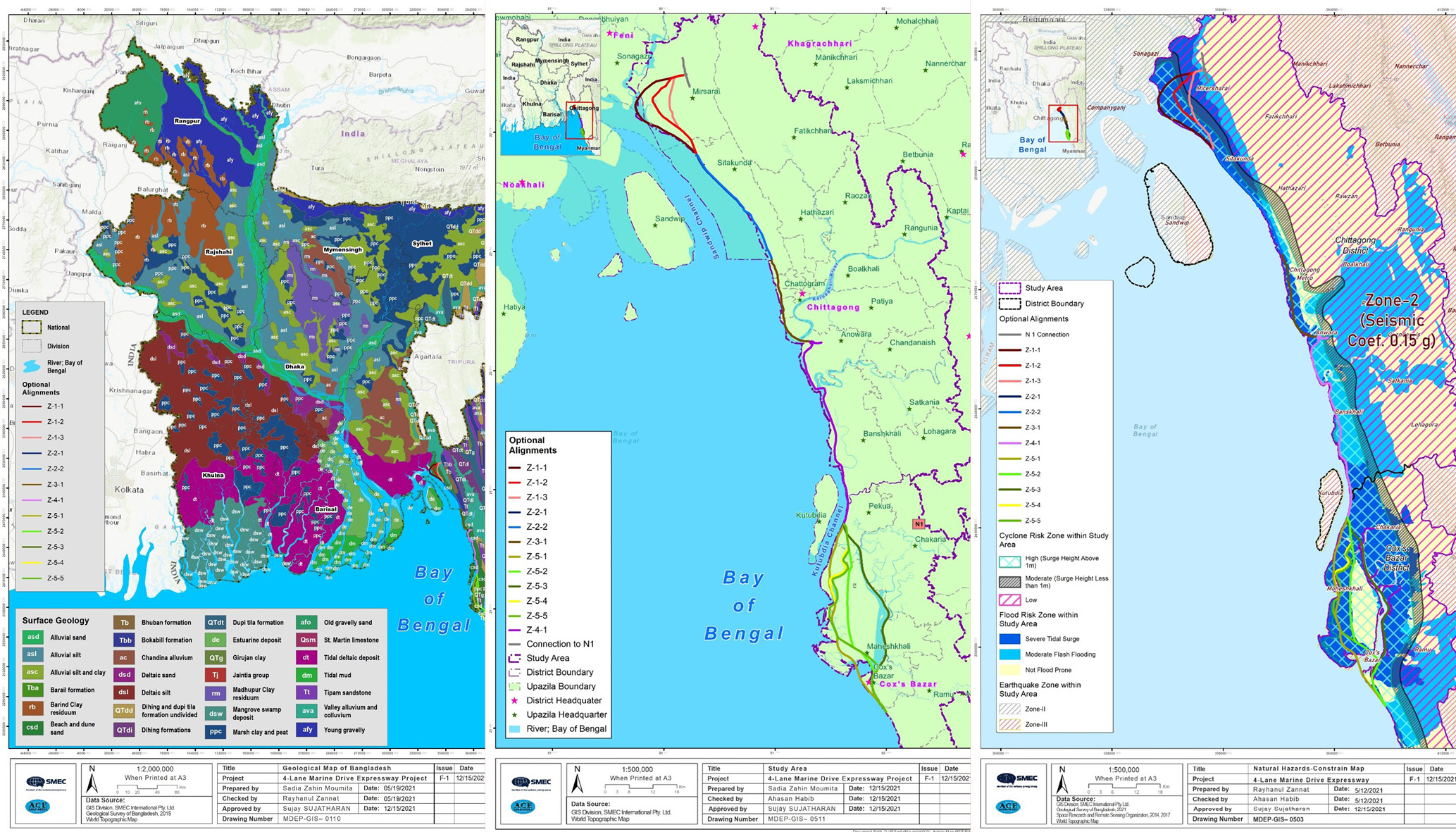
One area where GIS has proven invaluable is in the preliminary alignment of the highway. The alignment study was done during feasibility phase where GIS has provided an optimum tool to create constraint maps. With an understanding of available space and potential social and environmental impacts, GIS also facilitated the drafting of various alignment options. By overlaying GIS data with information on interfacing projects and corridor allocations, the project team could make informed decisions during the feasibility study. This approach saved costs, reduced rework, and accelerated the overall proficiency of the project.


Marine Drive Expressway has been divided into five different zones, each with specific priorities and considerations. By assigning appropriate weightage values, the GIS software provides an optimal route for each zone. For example, in Zone 01, high priority is given to Mirsharai Economic Zone. This zone-based analysis helps determine alternative routes based on specific criteria, to find a balance between distance and overcoming obstacles efficiently.


Coordinate systems play a crucial role as they define the latitude, longitude, vertical, and time axes for different projection systems. It is essential to have clarity about the projection system information when working with data from external sources. Without proper coordination, there is a risk of misrepresenting the area or shape of a feature, especially when dealing with data that uses different projection systems.


Social and environmental impact assessment

Social assessment is a crucial aspect of any highway project, ensuring that the alignment is planned in a way that minimises impacts on communities and preserves culturally significant assets.  For the Marine Drive Expressway, the GIS team captured Community Property Resources (CPR) locations, land use details, study area alignments, and other relevant information in a GIS file format known as KMZ.  GIS technology proved invaluable in swiftly identifying important features such as mosques, temples, schools, colleges, and universities within the study area.


GIS also played a critical role in conducting the Environmental Impact Assessment (EIA). The GIS team provided land use information to the environmental team, allowing them to predict the environmental impact after project implementation.


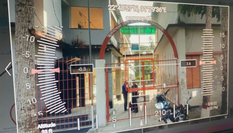
In certain locations, dense forest areas hindered visibility, necessitating physical visits to capture missing features. However, the process enabled the social team to optimise field studies and efficiently collect all the necessary information within a span of just two weeks.  Using the data captured from field visits, the GIS team obtained precise details such as latitude, longitude, altitude, capture angle, and zoom level, providing essential context for updating GIS and web GIS data accordingly. This approach improved accuracy and enabled better-informed planning and resource allocation.


Land use mapping

GIS facilitated the creation of land use maps for different options, categorising data based on community, property, and resource types. This again, eliminated the need for extensive field visits and streamlined decision-making.

  • Geology: GIS was used to map the composition of sedimentary rocks and geological formations, assisting the team in assessing the stability of the land and potential challenges related to ground conditions during the construction.
  • Seismic Conditions: Considering seismic activity was crucial to ensure the integrity of structures as well as ongoing safety. Subsequently the team was able to design appropriate measures to withstand potential earthquakes and minimise risks.
  • Topography: The flat and low-lying topography of Bangladesh has implications for the alignment and construction. Bespoke engineering solutions were needed to manage drainage, flood protection, and the stability of the road in low-lying areas.
  • Land Ownership: Understanding the land ownership structure was essential for land acquisition processes and engaging with landowners impacted.
  • Environmental Land Use: Considering the existing environmental land use, such as forests, wetlands, and protected areas, was crucial to minimising environmental impacts and ensuring compliance with environmental regulations.
  • Property Types: Knowledge of property types, including residential, commercial, agricultural, and industrial areas, was important for assessing the potential impacts of the expressway on existing infrastructure, communities, and economic activities.
  • Economic analysis: utilizing HDM4 and TUBA software, the GIS team analysed road network data and created road sections based on traffic volume and road conditions, streamlining the economic analysis process.


Application of GIS on Marine Drive Expressway, Bangladesh (Part 1)

Conclusion

The implementation of web GIS provided access to alignment information, background information (such as administrative boundaries and transport infrastructures), and project-specific details through an intuitive platform accessible via a browser and an internet connection. This solution reduced paper usage, facilitated communication, and simplified decision-making processes.

From preliminary alignment options to environmental assessments, traffic surveys, and economic analysis, GIS has proven to be a valuable tool for reducing costs, increasing efficiency, and improving overall project management.

In developing a bespoke, web-based GIS system, Marine Drive Expressway exemplifies the transformative potential of spatial data analysis and visualization in a large-scale infrastructure development. The integration of GIS has not only optimized decision-making but has also contributed to time and cost savings while ensuring a more sustainable and environmentally conscious project implementation.
Related
insights

View all